
Hong Kong’s typhoon season occurs from May to November. During peak times in July, August, and September, there is a 50-60% chance of a typhoon. Although typhoons rarely hit Hong Kong directly, they still have the power to cause severe damage, especially for people living on the outlying islands or low-lying areas.
Formally called tropical cyclone warning signals, typhoon signals are meant to give the public plenty of warning about the potentially destructive effects of wind and rain associated with a tropical storm.
How do typhoons form?
‘Typhoon’ and ‘hurricane’ are different names for the same phenomenon of cyclones over the sea. The difference in terminology comes from where the storm occurs geographically. In North America and the Carribean, the term hurricane is used. In Southeast Asia, the same phenomenon is called a typhoon. The generic term tropical cyclone is used in the South Pacific and Indian Ocean.
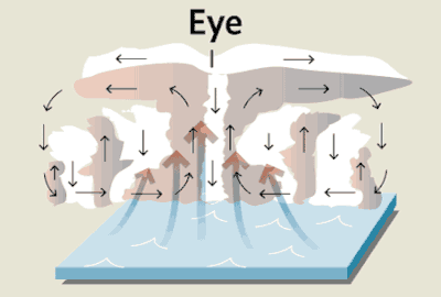
This type of weather disturbance occurs when there is a tropical thunderstorm over warm oceans. The strong winds pull in moisture from the water, leaving a deficit of air near the water’s surface. More air rushes in to replace it, which also heats up and rises. All of this humid and warm air creates intense precipitation and wind which can cause monumental destruction on land.
A history of typhoon signals
The first method of warning the public about imminent severe winds was the typhoon gun. Placed in front of the Tsim Sha Tsui Police Barracks facing Victoria Harbour, the gun was fired once when a gale (a wind stronger than a breeze and lighter than a storm) was expected and twice when a typhoon force wind was expected.
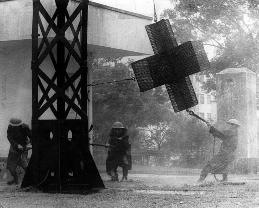
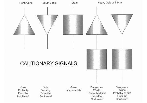
In 1897, Hong Kong adopted the system for signalling severe weather invented by English navy officer Robert Fitzroy. In the original basic system, when strong winds were expected, signals were hoisted on a mast for passing ships to see. A black cone pointing upwards signaled a gale blowing in a northern direction, and a cone pointing down signaled a southernly gale. A cylinder shape, or ‘drum’, was added below to indicate a gale that may reach hurricane force. At night, when the shapes couldn’t be seen, lights were used to indicate the shapes: three dots formed a triangle, four dots formed a square.
Combined with a numbering system implemented in 1931, the basis of shapes behind these storm cone signals are still the primary weather warning system in Hong Kong today.
What do the typhoon signals mean?
There are five categories in the tropical cyclone warning system: 1, 3, 8, 9 and 10. The raising of signal 9 or 10 is rare and indicates that destructive force is expected.
Typhoon Mangkhut in September 2018, one of the most destructive typhoons to near Hong Kong since 1999, hit signal 10.
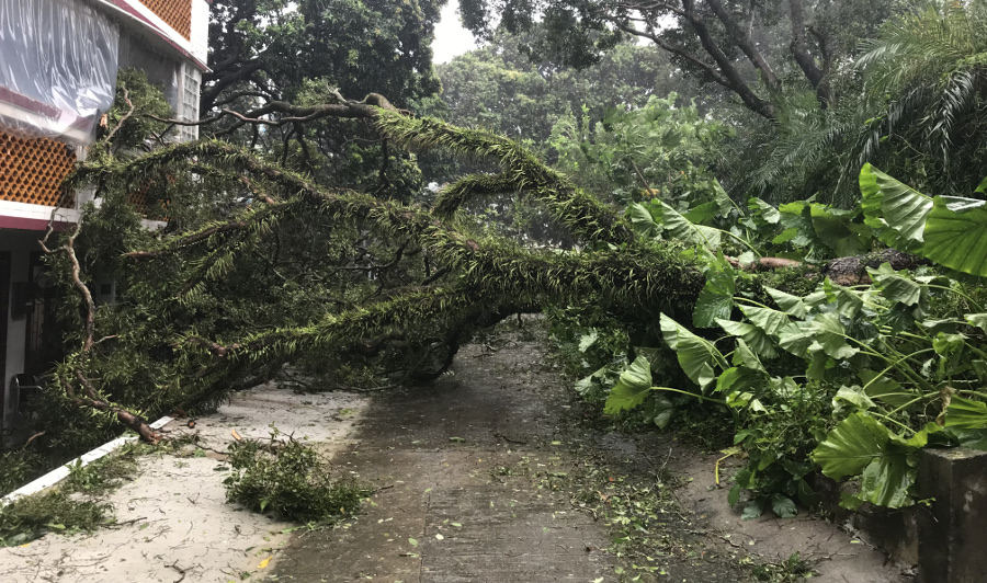
Typhoon Mangkhut wreaked havoc on infrastructure, smashing windows, separating roofs from buildings, interrupting electricity supply all over the city, and causing severe overcrowding on public transportation. Thankfully, the death toll was 0 and in the wake of the monster storm several memes were born.

So, why are there missing numbers in the tropical cyclone warning system? The original standardized numbering system was proposed by a conference of Eastern Asia weather bodies and did include 2, 4, 5, 6, and 7.
However, the hazards indicated by 2 and 4 were already conveyed in Hong Kong’s existing shape signals so they were omitted. Numbers 5 to 8 indicated the same wind severity but in different directions, and in 1973 these were changed to “8 + corresponding wind direction” to simplify the numbers’ meanings. Now, the public could understand at a glance that a bigger number meant a stronger wind.
| Signal | Name | Meaning |
 | Standby Signal No. 1 | A tropical cyclone is within approximately 800 kilometres of Hong Kong and may affect the territory. |
 | Strong Wind Signal No. 3 | Strong wind is blowing or expected to blow near sea level, with gusts which may exceed 110 km/h. Public transportation continues to run, but some cruises and flights may be cancelled. Kindergartens will close. |
 | No. 8 Northwest Gale or Storm Signal | Gale or storm force wind is blowing or expected to blow near sea level, with gusts that may exceed 180 km/h. Public transport, ferries, offices, schools, and stores close. |
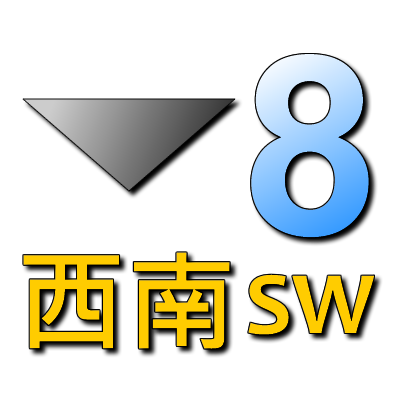 | No. 8 Southwest Gale or Storm Signal | See above. |
 | No. 8 Northeast Gale or Storm Signal | See above. |
 | No. 8 Southeast Gale or Storm Signal | See above. |
 | Increasing Gale or Storm Signal No. 9 | Gale or hurricane force wind is increasing or expected to increase significantly. |
 | Hurricane Signal No. 10 | Hurricane force wind is blowing or expected to blow with gusts that may exceed 220 km/h. |
Here is what to do during a typhoon in Hong Kong:
- T1: There is a storm nearby that may become a typhoon. Factor this possibility into outdoor plans, being mindful that strong winds may occur over offshore waters. Keep an eye out for weather updates on the HKO website or app, TV, and radio.
- T3: Low-lying areas may experience flooding or seawater backflow. Secure loose objects or take them indoors.
- T8: Winds are expected to reach gale force within 12 hours after this signal is issued. Return home or find other shelter well above sea level that can withstand gale force winds. If it’s safer to stay at work, do so. When the weather deteriorates suddenly and a no. 8 is expected in under 2 hours, a special pre-no. 8 announcement is made.
- Storm Signal 9 and T10: All safety precautions should be completed (i.e. under safe shelter, stocked up on water and food for a few days, large windows taped). Stay indoors and away from exposed windows and doors.
Other weather warnings
There are other warnings issued separately from the tropical cyclone warnings. The latter exclusively indicate the threat of winds associated with a cyclone. Combined with warnings for rainstorms or landslips, the HKO can create a clearer picture of what to expect and how to prepare for potential danger.
Rainstorm Warnings
Amber: Heavy rain exceeding 30 mL/hr has or is expected to fall, with possible flooding in low-lying areas and areas without sufficient drainage. You should: attend public examinations as normal, avoid bodies of water that may flood, and keep an eye out for heightened warnings.
Red: Heavy rainfall exceeding 50 mL/hr has or is expected to fall, which is likely to cause serious flooding, river overflow, and/or traffic jams. You should: stop working if your job requires you to be outside, but go to indoor work as usual if transportation is running normally and it’s safe to do so.
Black: Very heavy rainfall exceeding 70mL/hr has or expected to fall. You should: stay indoors until rain has passed, stop working and find shelter if you’re required to be outside, stay at work if it’s safer than returning home, or go to a temporary shelter operated by the Home Affairs Department if you have nowhere safe to go. (Call emergency hotline 2835 1473 to find the shelter nearest to you.)
Sometimes, the weather worsens so suddenly that a red warning is issued without a preceding amber, or a black warning is issued without a preceding red.
Strong Monsoon Signal
This signal is issued when winds associated with monsoon are at or exceeding 40km/h near sea level. The winter monsoon occurs from October to March, and the summer monsoon occurs from April to September. You should: bring objects likely to be blown away indoors, stay away from the shoreline as rough swells may affect the coast, and be aware of strong winds on freeways if you’re driving.
Special Announcement on Flooding in the Northern New Territories
This warning is issued when heavy rainfall makes flooding occur or likely to occur in the northern New Territories areas of Pat Heung, Kam Tin, Yuen Long, Ngau Tam Mei, San Tin, Sheung Shui, Ta Kwu Ling, and Sha Tau Kok. There have been enough cases of isolated rainstorms and subsequent flooding occurring in these lay-lowing regions to warrant a separate warning. A specialized announcement like this can be very important because avoiding false calls in unaffected areas keeps people sensitive to signals when they do affect them directly.
How do I know what the current typhoon signal is?
Go to the HKO website or call the Dial-a-Weather service at 1878 200. The Hong Kong Observatory posts the current tropical cyclone warning here.
If a typhoon signal has not been issued yet but the weather is becoming increasingly dangerous, it may be helpful to take a look at these radar images that track rain movement. The Observatory updates the page every 6-12 minutes showing the location, intensity, and direction of rain in and around Hong Kong.