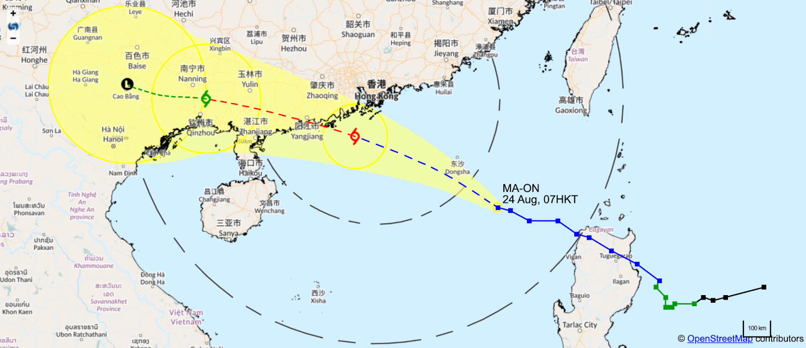
7AM (August 24) — On Wednesday 24, at 7AM, MA-ON, a severe tropical storm, was estimated to be 530 km southwest of Hong Kong and moving west-northwest at a pass of 25 km/h, over the northeastern part of the South China Sea, approaching the west coast of Guangdong, and strengthening slowly.
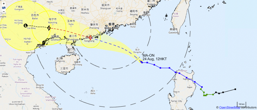
The forecast path shows that MA-ON will approach the Pearl River Estuary shortly, winds should strengthen tonight, prompting the Observatory to issue the Strong Wind Signal, No. 3 between noon and 2PM. The storm will be closest to Hong Kong tomorrow morning (25 August) and may pass within 200 km of the territory.

The Education Bureau also issued a special announcement explaining that, due to the weather conditions “classes of kindergartens, schools for children with physical disability and schools for children with intellectual disability are suspended today. These schools, however, should keep their premises open and implement contingency measures to look after arriving students. They should ensure that conditions are safe before allowing students to return home. Parents need not pick up their children from schools immediately.”.
12.40PM (August 24) — The Strong Wind Signal, No. 3 was issued at 12:40 p.m.
At 1 p.m., Severe Tropical Storm Ma-on was estimated to be about 440 kilometres southeast of Hong Kong (near 19.4 degrees north 117.0 degrees east) and is forecast to move west-northwest at about 25 kilometres per hour in the general direction of the coast of western Guangdong.
The outer rainbands associated with Ma-on are edging close to the vicinity of the Pearl River Estuary. There will be squally showers and thunderstorms over Hong Kong later today and local winds will strengthen rapidly tonight. The Observatory will consider issuing the No. 8 Gale or Storm Signal between 6 p.m. and 9 p.m. today. There will be rough to high seas and swells. Members of the public are advised to stay away from the shoreline and not to engage in water sports.

According to the present forecast track, Ma-on is expected to be closest to Hong Kong tomorrow morning and may skirt within about 200 kilometres south-southwest of the territory, posing a considerable threat to the territory. Under the influence of storm surge and astronomical high tide, a high water level of around 3 metres above chart datum is expected at Quarry Bay between 5 a.m. and 9 a.m tomorrow, or about 1 metre above the normal tide heights. The high water level may cause flooding in low-lying areas.
Members of the public should take note of the latest information issued by the Observatory and complete precautionary measures against high winds and flooding as soon as possible.
7AM (August 25) — At 7 a.m., Severe Tropical Storm Ma-on was centred about 250 kilometres southwest of Hong Kong (near 21.0 degrees north 112.2 degrees east) and is forecast to move west-northwest at about 28 kilometres per hour in the general direction of the coast of western Guangdong.
Ma-on is moving away from Hong Kong. Local winds will weaken gradually. Depending on the degree of weakening of local winds, the Observatory will consider issuing the Strong Wind Signal, No. 3 to replace the No. 8 Gale or Storm Signal between 9 a.m. and 11 a.m.
The Education Bureau issued the following statement at 5.10 AM this morning, to clarify about the school situation “As the Tropical Cyclone Warning Signal no. 8 is now in force, classes of all AM and whole-day schools (including kindergartens, schools for children with physical disability, schools for children with intellectual disability, primary and secondary schools) are suspended today. If the Hong Kong Observatory replaces it with the Tropical Cyclone Warning Signal no. 3 before 10:30 am, classes of PM primary and secondary schools and classes of evening schools will resume today. If the Hong Kong Observatory replaces it with the Tropical Cyclone Warning Signal no. 1 or cancels all signals before 10:30 am, classes of PM schools and classes of evening schools will resume today.”.
🌀 More about typhoons in Hong Kong 🌀
Source:

![[UPDATE] Tropical Storm MA-ON : T3 To Replace T8 Between 9AM And 11AM, Schools Suspended Unless Changes Before 10.30AM ma on storm 6am 2508202](https://thehkhub.com/wp-content/uploads/2022/08/ma-on-storm-6am-2508202.jpg)
